


The National Weather Service in Little Rock has issued a* Severe Thunderstorm Warning for…
Northern Grant County in central Arkansas…
North central Dallas County in southwestern Arkansas…
Southeastern Saline County in central Arkansas…
Southeastern Hot Spring County in southwestern Arkansas…
* Until 330 PM CDT
* At 256 PM CDT, a severe thunderstorm was located 10 miles southwest of Thiel, or 13 miles south of Malvern, moving northeast at 55 mph.
HAZARD…Ping pong ball size hail and 60 mph wind gusts.
SOURCE…Radar indicated.
IMPACT…People and animals outdoors will be injured. Expect hail damage to roofs, siding, windows, and vehicles. Expect wind damage to roofs, siding, and trees.
* Locations impacted include…
Benton… Malvern… Sheridan… Haskell… Traskwood… Tull… Prattsville… Poyen… Perla… Cane Creek… Jenkins Ferry State Park… Thiel… Dogwood… Bauxite… Belfast… Lono… Gifford… Shaw… Glen Rose… Buie…
This includes Interstate 30 between mile markers 107 and 109.
A tornado watch remains in effect until 500 PM CDT for central and
southwestern Arkansas.
HAIL…1.50IN
WIND…60MPH
Area: DALLAS; GRANT; HOT SPRING; SALINE
TORNADO WATCH ISSUED APRIL 26 AT 10:05AM CDT UNTIL APRIL 26 AT 5:00PM CDT
TORNADO WATCH 162 IS IN EFFECT UNTIL 500 PM CDT FOR THE FOLLOWING LOCATIONS IN AR
ARKANSAS; BAXTER; BRADLEY; CALHOUN; CLARK; CLAY; CLEBURNE; CLEVELAND; COLUMBIA; CONWAY; CRAIGHEAD; CROSS; DALLAS; DESHA; DREW; FAULKNER; FULTON; GARLAND; GRANT; GREENE; HEMPSTEAD; HOT SPRING; HOWARD; INDEPENDENCE; IZARD; JACKSON; JEFFERSON; LAFAYETTE; LAWRENCE; LEE; LINCOLN; LITTLE RIVER; LONOKE; MILLER; MONROE; MONTGOMERY; NEVADA; OUACHITA; PERRY; PHILLIPS; PIKE; POINSETT; POPE; PRAIRIE; PULASKI; RANDOLPH; SALINE; SEARCY; SEVIER; SHARP; ST. FRANCIS; STONE; UNION; VAN BUREN; WHITE; WOODRUFF; YELL
Instructions:
- VIEW STORM REPORTS MAP.
- KNOW THE DIFFERENCE BETWEEN WATCH, WARNING, ADVISORY
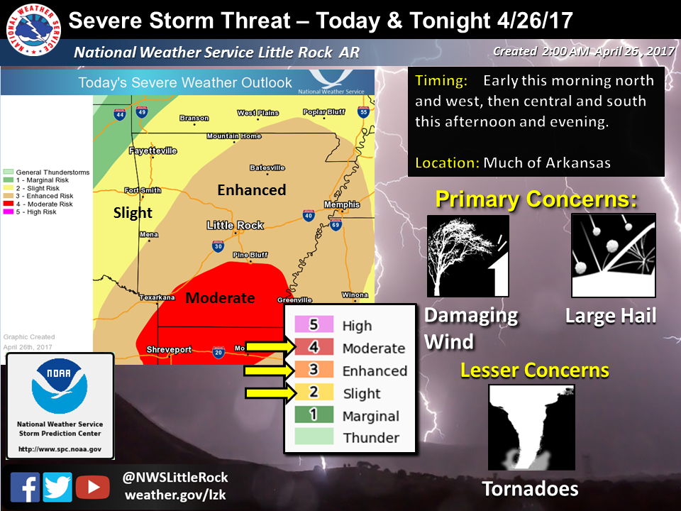
A strong storm system will move across Arkansas today and tonight. Showers and thunderstorms will become likely in much of the state during the mid-morning and afternoon, and will continue into tonight, with severe thunderstorms possible.
Timing-wise, the greatest thunderstorm potential will be in western Arkansas from mid-morning through early evening (9 AM to around 6 PM), in central Arkansas from late afternoon through mid-evening (around 4 PM to 10 PM), and in eastern Arkansas between early evening and very early morning (around 7 PM to 1 AM).
The primary concern with any severe thunderstorms will be damaging wind gusts in excess of 60 MPH, and large hail in excess of one inch in diameter. Tornadoes will also be possible.
Storm mode will initially start out as individual, discrete cells. As a cold front moves into the state during the late afternoon, storms will develop in a line along or just ahead of the front. The tornado potential will be highest in the cells out ahead of the front, though with the amount of low level wind shear present with this system, there could be some spin-ups in portions of the line. As the evening progresses, this will evolve into more of a wind threat.
The highest concern for severe thunderstorms will be in areas mainly east of a Mena to Mountain Home line.
Stronger storms will also be capable of producing localized heavy rainfall, with an inch or two possible in a short period of time.
There is increasing concern for potential severe thunderstorms at the end of this week into the weekend. All modes of severe weather would be possible, particularly over the western portion of the state, and during the Friday afternoon into Saturday time frame.There is also increasing concern for potential heavy rainfall on Saturday into Sunday. The latest model forecasts are showing as much as four to six inches of rain possible in most of the state. This would lead to flash flooding concerns, and some river flooding concerns in several basins.As always, please continue to monitor the latest information from your Arkansas National Weather Service Forecast Offices, and be prepared to take action if a watch or warning is issued for your area.